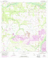
1955 Map of Lithia
USGS Topo · Published 1988About this map
The Alafia River and its numerous prongs dictate the landscape of this Florida region, creating a network of hammocks such as Cabbage Hammock and Stallion Hammock. This 1955 survey, with updates through the 1980s, captures the transition of the land from native wetlands and small settlements like Boyette and Pinecrest toward intensive phosphate extraction. The presence of Strip Mine and Reclaimed Strip Mine areas illustrates the significant industrial footprint of the era, while the CSX railroad corridor provided the necessary transit for these resources.
Find a feature on this map
41 named features on this map. Tap any name to fly to it.
Don’t see what you’re looking for? This feature index may not catch every label — zoom into the map to look around manually.
Map Details
Editions of this 1955 Lithia Map
4 editions found
Other maps of this area

1921 · Tampa
USGS Topo · 1:62,500

1944 · Mango
USGS Topo · 1:31,680

1944 · Wimauma
USGS Topo · 1:31,680

1944 · Balm
USGS Topo · 1:31,680

1947 · Wimauma
USGS Topo · 1:25,000

1955 · Lithia
USGS Topo · 1:24,000

1955 · Nichols
USGS Topo · 1:24,000

1955 · Dover
USGS Topo · 1:24,000

1955 · Keysville
USGS Topo · 1:24,000
1956 · Riverview
USGS Topo · 1:24,000