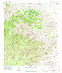
1972 Map of Little Aguja Mountain
USGS Topo · Published 1975About this map
Timber Mountain and Forbidden Mountain dominate this corner of the Davis Mountains, where steep relief is marked by a complex system of pack trails and isolated springs. The presence of Madera Springs Lodge and the Buffalo Trail Scout Camp suggests the area’s 20th-century transition into a space for recreation and youth education, though the landscape remains largely defined by its natural defenses. Named landmarks like Rustlers Flat and The Role Pens hint at a history of ranching and livestock management in the high country. Numerous water sources such as the Blue Hole and Orchard Spring are critical points in an otherwise arid terrain, connected by a network labeled simply as Pack Trail. Distinctive geologic features, including Balance Rock and Needle Rock, serve as natural waypoints through Madera Canyon and Little Aguja Canyon.
Find a feature on this map
50 named features on this map. Tap any name to fly to it.
Don’t see what you’re looking for? This feature index may not catch every label — zoom into the map to look around manually.
Map Details
Editions of this 1972 Little Aguja Mountain Map
This is the sole edition of this map. No revisions or reprints were ever made.
Other maps of this area

1894 · Valentine
USGS Topo · 1:125,000

1894 · Fort Davis
USGS Topo · 1:125,000

1897 · Valentine
USGS Topo · 1:125,000

1897 · Fort Davis
USGS Topo · 1:125,000

1943 · Valentine
USGS Topo · 1:125,000

1954 · Fort Stockton
USGS Topo · 1:250,000

1958 · Fort Stockton
USGS Topo · 1:250,000

1959 · Marfa
USGS Topo · 1:250,000

1965 · Marfa
USGS Topo · 1:250,000

1972 · Casket Mountain
USGS Topo · 1:24,000