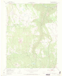
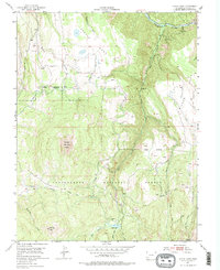
1953 Map of Little Cone
USGS Topo · Published 1970About this map
Little Cone stands as the dominant topographical landmark in this high-altitude section of the Uncompahgre National Forest during the early 1950s. The landscape is defined by broad tablelands including Specie Mesa and Wilson Mesa, which are deeply incised by the drainage systems of Specie Creek, Fall Creek, and the San Miguel River. The settlement of Saw Pit sits along the river at the northern edge, serving as a rare point of habitation in a region primarily used for timber, grazing, and resource extraction. Evidence of the area's mining history is found in the Silver Pick Basin at the southern margin. The presence of numerous labeled pack trails and a gaging station suggests a rugged environment where water management and backcountry access were primary concerns for the United States Atomic Energy Commission and the Geological Survey at the time of this field check.
Find a feature on this map
21 named features on this map. Tap any name to fly to it.
Don’t see what you’re looking for? This feature index may not catch every label — zoom into the map to look around manually.
Map Details
Editions of this 1953 Little Cone Map
6 editions found
Other maps of this area

1897 · Telluride
USGS Topo · 1:62,500

1904 · Telluride
USGS Topo · 1:62,500

1909 · Montrose
USGS Topo · 1:125,000

1911 · Montrose
USGS Topo · 1:125,000

1945 · Durango
USGS Topo · 1:250,000

1953 · Mount Wilson
USGS Topo · 1:24,000

1953 · Dolores Peak
USGS Topo · 1:24,000

1953 · Placerville
USGS Topo · 1:24,000
1953 · Gray Head
USGS Topo · 1:24,000

1953 · Little Cone
USGS Topo · 1:24,000