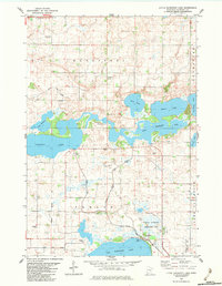
1982 Map of Little Kandiyohi Lake
USGS Topo · Published 1983About this map
The Little Kandiyohi Lake basin in central Minnesota anchors a landscape defined by an intricate network of interconnected glacial lakes and managed waterways. In the early 1980s, this area of Kandiyohi and Fahlun townships shows a transition from agricultural land use toward natural resource preservation, evidenced by the National Waterfowl Production Area and County Park No 2. Significant water bodies like Wagonga Lake, Swan Lake, and Lake Eleanor are linked by drainage channels and the South Fork Crow River No 1. Local heritage is preserved in clusters of community markers, including the Tripolis Church and its accompanying cemetery, alongside Oak Park Church and Oak Hill Cemetery. The map also details the technical infrastructure of the era, such as a Pumping Station and several Gravel Pits, reflecting both the environmental management and extractive industries of the period.
Find a feature on this map
27 named features on this map. Tap any name to fly to it.
Don’t see what you’re looking for? This feature index may not catch every label — zoom into the map to look around manually.
Map Details
Editions of this 1982 Little Kandiyohi Lake Map
This is the sole edition of this map. No revisions or reprints were ever made.
Other maps of this area

1953 · New Ulm
USGS Topo · 1:250,000

1953 · Saint Cloud
USGS Topo · 1:250,000

1956 · Atwater
USGS Topo · 1:62,500

1957 · Saint Cloud
USGS Topo · 1:250,000

1957 · New Ulm
USGS Topo · 1:250,000

1957 · Olivia
USGS Topo · 1:62,500

1958 · New Ulm
USGS Topo · 1:250,000

1958 · Saint Cloud
USGS Topo · 1:250,000

1958 · Willmar
USGS Topo · 1:24,000

1958 · Solomon Lake
USGS Topo · 1:24,000