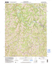
1998 Map of Littleton
USGS Topo · Published 2000About this map
Fish Creek winds through the hills of the Northern Panhandle and North Central West Virginia, defining a landscape marked by small ridge-top settlements and narrow hollows. In this part of Wetzel Co and Marshall Co, community life is anchored by rural institutions like Miller Chapel, Kick Ridge Ch, and the Board Tree school. The map reveals a high density of family-centric landmarks, including the Jolliffee Cem, Meadowdale Cem, and Carney Cems, which offer significant value for genealogical research into the families of Littleton and surrounding hamlets like Endicott and Anthem. The terrain is characterized by prominent elevations such as Kaub Knob and Denver Heights, while the presence of Quarries and numerous unnamed wells indicates the region's reliance on extractive industries. This survey captures the traditional settlement patterns of the borderlands between West Virginia and Pennsylvania before the further modernization of the late 20th century.
Find a feature on this map
72 named features on this map. Tap any name to fly to it.
Don’t see what you’re looking for? This feature index may not catch every label — zoom into the map to look around manually.
Map Details
Editions of this 1998 Littleton Map
This is the sole edition of this map. No revisions or reprints were ever made.
Other maps of this area

1903 · Littleton
USGS Topo · 1:62,500

1904 · Cameron
USGS Topo · 1:62,500

1905 · Mannington
USGS Topo · 1:62,500

1905 · Rogersville
USGS Topo · 1:62,500

1905 · Littleton
USGS Topo · 1:62,500

1923 · Mannington
USGS Topo · 1:62,500

1924 · Littleton
USGS Topo · 1:62,500

1926 · Littleton
USGS Topo · 1:62,500

1926 · Mannington
USGS Topo · 1:62,500

1935 · Cameron
USGS Topo · 1:62,500