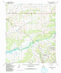
1952 Map of Livengood A-2
USGS Topo · Published 1992About this map
Gold mining operations and infrastructure dominate this landscape north of Fairbanks during the early 1950s. The presence of tailings and several mining-related settlements like Dome Camp, Eldorado Camp, and Pedro Camp reflect the region's industrial focus, particularly along the southern reaches near Pedro Dome. This interior Alaskan terrain is traversed by the Elliott Highway and an Old Railroad Grade, showing the evolution of transport in the subarctic.
Find a feature on this map
57 named features on this map. Tap any name to fly to it.
Don’t see what you’re looking for? This feature index may not catch every label — zoom into the map to look around manually.
Map Details
Editions of this 1952 Livengood A-2 Map
4 editions found

Other maps of this area

1945 · Livengood
USGS Topo · 1:250,000

1949 · Fairbanks D-1
USGS Topo · 1:62,500

1949 · Fairbanks D-2
USGS Topo · 1:62,500

1949 · Fairbanks D-3
USGS Topo · 1:63,360

1950 · Fairbanks
USGS Topo · 1:250,000

1950 · Fairbanks D-3
USGS Topo · 1:63,360

1951 · Fairbanks
USGS Topo · 1:250,000

1951 · Livengood
USGS Topo · 1:250,000

1951 · Livengood B-2
USGS Topo · 1:63,360

1952 · Fairbanks D-2
USGS Topo · 1:63,360