
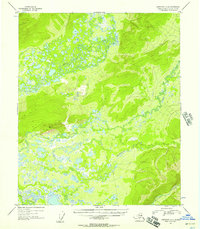
1953 Map of Livengood A-4
USGS Topo · Published 1955About this map
The Tolovana River and Tatalina River dominate this interior landscape, winding through a complex network of wetlands and low-lying hills north of Fairbanks. The terrain is defined by its dramatic relief, rising from the saturated marshlands to the prominent high point at VABM 1364 Minto. This 1953 survey captures the region's wilderness character just before the mid-century period of Alaskan expansion, showing a landscape almost entirely devoid of permanent modern infrastructure.
Find a feature on this map
7 named features on this map. Tap any name to fly to it.
Don’t see what you’re looking for? This feature index may not catch every label — zoom into the map to look around manually.
Map Details
Editions of this 1953 Livengood A-4 Map
2 editions found
Other maps of this area

1945 · Livengood
USGS Topo · 1:250,000

1949 · Fairbanks D-3
USGS Topo · 1:63,360

1949 · Fairbanks D-4
USGS Topo · 1:63,360

1950 · Fairbanks
USGS Topo · 1:250,000

1950 · Fairbanks D-5
USGS Topo · 1:63,360

1950 · Fairbanks D-3
USGS Topo · 1:63,360

1951 · Fairbanks
USGS Topo · 1:250,000

1951 · Livengood
USGS Topo · 1:250,000

1951 · Livengood A-5
USGS Topo · 1:63,360

1951 · Livengood A-4
USGS Topo · 1:63,360