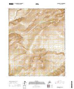
2017 Map of Livengood C-2 SW
USGS Topo · Published 2017About this map
Tolovana River winds through the northern reaches of this Yukon-Koyukuk interior, establishing a drainage pattern that defines the local topography. This 2017 survey illustrates a landscape primarily shaped by its waterways, including the Tutalina River which flows across the southern sections. The map reveals the intricate network of tributaries that feed these larger rivers, such as Duncan Cr and Colorado Cr. Organized under the Public Land Survey System, the terrain is divided into townships including t9n r2w and t9n r1w, reflecting the systematic grid used to manage this expansive Alaskan wilderness. The contour lines trace significant elevation changes between the river valleys, providing a clear picture of the watershed as it stood in the early 21st century.
Find a feature on this map
8 named features on this map. Tap any name to fly to it.
Don’t see what you’re looking for? This feature index may not catch every label — zoom into the map to look around manually.
Map Details
Editions of this 2017 Livengood C-2 SW Map
This is the sole edition of this map. No revisions or reprints were ever made.
Other maps of this area

1945 · Livengood
USGS Topo · 1:250,000

1951 · Livengood
USGS Topo · 1:250,000

1951 · Livengood C-2
USGS Topo · 1:63,360

1951 · Livengood B-2
USGS Topo · 1:63,360

1954 · Livengood C-2
USGS Topo · 1:63,360

1954 · Livengood B-3
USGS Topo · 1:63,360
1954 · Livengood B-2
USGS Topo · 1:63,360
1954 · Livengood C-3
USGS Topo · 1:63,360

1956 · Livengood
USGS Topo · 1:250,000

1964 · Livengood
USGS Topo · 1:250,000