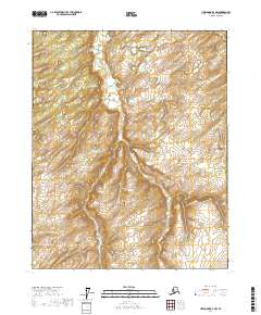
2017 Map of Livengood D-3 NW
USGS Topo · Published 2017About this map
Alfred Cr winds through this interior Alaskan wilderness, following a deep topographical course that cuts across the land. The drainage patterns of the creek and its numerous unnamed tributaries define the character of the terrain, which is dominated by a complex network of high ridges and narrow valleys. This 2017 survey by the U.S. Geological Survey documents the raw physical geography of the Livengood D-3 NW region, a landscape where natural watercourses are the primary identifiers of location. The absence of named settlements or roads reflects the persistent isolation of the Yukon-Koyukuk Census Area. Genealogists and researchers looking for family mining claims or historical wilderness access points can use the detailed contour lines to identify specific elevations and landforms that would have dictated movement through this subarctic environment.
Find a feature on this map
10 named features on this map. Tap any name to fly to it.
Don’t see what you’re looking for? This feature index may not catch every label — zoom into the map to look around manually.
Map Details
Editions of this 2017 Livengood D-3 NW Map
This is the sole edition of this map. No revisions or reprints were ever made.
Other maps of this area

1945 · Livengood
USGS Topo · 1:250,000

1951 · Livengood
USGS Topo · 1:250,000

1951 · Beaver
USGS Topo · 1:250,000

1951 · Livengood D-3
USGS Topo · 1:63,360

1953 · Livengood D-4
USGS Topo · 1:63,360

1954 · Livengood D-4
USGS Topo · 1:63,360
1954 · Livengood D-3
USGS Topo · 1:63,360

1956 · Beaver A-3
USGS Topo · 1:63,360

1956 · Beaver
USGS Topo · 1:250,000

1956 · Beaver A-4
USGS Topo · 1:63,360