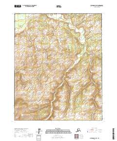
2017 Map of Livengood D-4 NE
USGS Topo · Published 2017About this map
Rogers Cr and Ross Cr carve through the high interior of the Yukon-Koyukuk region, defining the drainage patterns of this Alaskan landscape. This 2017 study illustrates the complex topography of the Livengood area, where high ridges and deep valleys are segmented by the Public Land Survey System grids of t14n r6w, t13n r5w, and several adjacent townships. The map documents the natural course of Fox Cr in the southeastern quadrant, offering a detailed record of the undeveloped wilderness before modern shifts in land use or environmental change. While the area remains largely free of permanent settlements or infrastructure, the naming of these specific drainages provides essential orientation for researchers studying the geographic history and land partitions of northern Alaska.
Find a feature on this map
9 named features on this map. Tap any name to fly to it.
Don’t see what you’re looking for? This feature index may not catch every label — zoom into the map to look around manually.
Map Details
Editions of this 2017 Livengood D-4 NE Map
This is the sole edition of this map. No revisions or reprints were ever made.
Other maps of this area

1945 · Livengood
USGS Topo · 1:250,000

1951 · Livengood
USGS Topo · 1:250,000

1951 · Beaver
USGS Topo · 1:250,000

1951 · Livengood D-3
USGS Topo · 1:63,360

1953 · Livengood D-4
USGS Topo · 1:63,360

1954 · Livengood D-4
USGS Topo · 1:63,360
1954 · Livengood D-3
USGS Topo · 1:63,360

1956 · Beaver A-3
USGS Topo · 1:63,360

1956 · Beaver
USGS Topo · 1:250,000

1956 · Beaver A-4
USGS Topo · 1:63,360