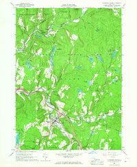
1965 Map of Livingston Manor
USGS Topo · Published 1967About this map
Livingston Manor serves as the focal point of this Catskill region mid-century landscape, situated at the confluence of Willowemoc Creek and the Little Beaver Kill. The mid-1960s terrain shows a well-established recreational and institutional presence, with numerous summer camps such as Our Lady of Lourdes Camp and Camp Raleigh dotting the shorelines of glacial waters like Waneta Lake and White Roe Lake. This period captures the early years of the modern interstate era, evidenced by Interchange 96 and Interchange 97 along the highway corridor through the valley.
Find a feature on this map
77 named features on this map. Tap any name to fly to it.
Don’t see what you’re looking for? This feature index may not catch every label — zoom into the map to look around manually.
Map Details
Editions of this 1965 Livingston Manor Map
3 editions found
Other maps of this area

1901 · Margaretville
USGS Topo · 1:62,500

1904 · Margaretville
USGS Topo · 1:62,500

1910 · Neversink
USGS Topo · 1:62,500

1921 · Livingston Manor
USGS Topo · 1:62,500

1922 · Andes
USGS Topo · 1:62,500

1923 · Livingston Manor
USGS Topo · 1:62,500

1924 · Andes
USGS Topo · 1:62,500

1942 · Neversink
USGS Topo · 1:62,500

1943 · Monticello
USGS Topo · 1:125,000

1944 · Livingston Manor
USGS Topo · 1:62,500