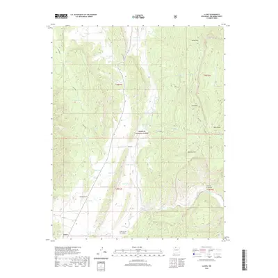
2020 Map of Llaves
USGS Topo · Published 2020About this map
Llaves sits at the southwestern edge of a high-elevation landscape dominated by the Santa Fe National Forest and the imposing Gallina Mountain. This 2020 survey documents a complex system of water management in an arid environment, characterized by numerous named tanks such as Sawmill Tank, Mister Tank, and Fickle Tank used to support livestock and land use. The drainage patterns are defined by the Rio Gallina and seasonal watercourses like Arroyo Archuleta and Chupadero Arroyo. The terrain rises sharply from the valley floor toward prominent landmarks including Gallina Peak and Dead Man Peak. These geographic features reflect a legacy of ranching and forestry, where the naming of small water sources like Alkali Spring or Pollywog Pond was vital for navigation and survival in the Rio Arriba backcountry.
Find a feature on this map
48 named features on this map. Tap any name to fly to it.
Don’t see what you’re looking for? This feature index may not catch every label — zoom into the map to look around manually.
Map Details
Editions of this 2020 Llaves Map
This is the sole edition of this map. No revisions or reprints were ever made.
Other maps of this area

1909 · Gallina
USGS Topo · 1:125,000

1953 · Laguna Peak
USGS Topo · 1:24,000

1953 · Navajo Peak
USGS Topo · 1:24,000

1954 · Aztec
USGS Topo · 1:250,000

1955 · Llaves
USGS Topo · 1:62,500

1955 · Tierra Amarilla
USGS Topo · 1:62,500

1955 · Boulder Lake
USGS Topo · 1:62,500

1958 · Aztec
USGS Topo · 1:250,000

1962 · Aztec
USGS Topo · 1:250,000

1965 · Aztec
USGS Topo · 1:250,000