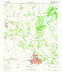
1963 Map of Lockhart North
USGS Topo · Published 1974About this map
The town of Lockhart anchors the southern edge of this survey, serving as a hub for the surrounding central Texas agricultural landscape. The Missouri Kansas Texas railroad cuts through the terrain, paralleling the course of Plum Creek and its many tributaries, such as Elm Creek and Boggy Creek. Several flood control reservoirs, identified as Site No 18, Site No 20, and Site No 21, indicate mid-century water management efforts across the watershed. Rural life is evidenced by a high density of local burial grounds and schools, including the St Pablo Cem and Polonia Cem, along with the Carver High Sch within the town limits. The map also captures the transition from open fields to the developed streets of the city, including sites like the Hospital and various Gravel Pits.
Find a feature on this map
34 named features on this map. Tap any name to fly to it.
Don’t see what you’re looking for? This feature index may not catch every label — zoom into the map to look around manually.
Map Details
Editions of this 1963 Lockhart North Map
3 editions found

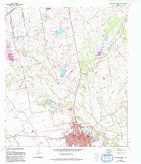
Other maps of this area

1896 · Austin
USGS Topo · 1:125,000

1897 · Austin
USGS Topo · 1:125,000

1910 · Austin
USGS Topo · 1:125,000

1911 · San Marcos
USGS Topo · 1:125,000

1919 · San Marcos
USGS Topo · 1:125,000

1925 · San Marcos 1-d
USGS Topo · 1:48,000

1930 · Lockhart
USGS Topo · 1:62,500

1953 · Seguin
USGS Topo · 1:250,000

1954 · Austin
USGS Topo · 1:250,000

1955 · Montopolis
USGS Topo · 1:62,500