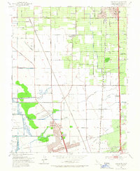
1953 Map of Lodi South
USGS Topo · Published 1966About this map
Mokelumne River and the Calaveras River frame this agricultural landscape between the growing city centers of Lodi and the City of Stockton. The 1950s period is visible in the transition from traditional farmsteads to suburban developments like Lincoln Village and Henderson Village. The area is densely networked with transportation infrastructure, from the Western Pacific and Southern Pacific railroads to specialized aviation sites like Lodi Airport and Oranges Airport. Rural life is anchored by local institutions such as Lafayette School, Elkhorn Sch, and Cherokee Memorial Park. Water management is a defining characteristic of the terrain, evidenced by the extensive Aqueduct, numerous Levee systems, and the low-lying tracts of the Atlas Tract and Shima Tract. Industrial activity is noted at the Tom railway siding with its local Cannery.
Find a feature on this map
58 named features on this map. Tap any name to fly to it.
Don’t see what you’re looking for? This feature index may not catch every label — zoom into the map to look around manually.
Map Details
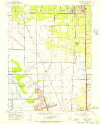
Editions of this 1953 Lodi South Map
2 editions found
Other maps of this area

1894 · Lodi
USGS Topo · 1:125,000

1908 · Waterloo
USGS Topo · 1:31,680

1908 · Lockeford
USGS Topo · 1:31,680

1910 · New Hope
USGS Topo · 1:31,680

1910 · Castle
USGS Topo · 1:31,680

1910 · Woodbridge
USGS Topo · 1:31,680

1910 · Headreach
USGS Topo · 1:31,680

1913 · Stockton
USGS Topo · 1:31,680

1913 · Holt
USGS Topo · 1:31,680

1914 · Burnham
USGS Topo · 1:31,680