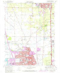
1968 Map of Lodi South
USGS Topo · Published 1977About this map
Stockton and Lodi dominate the landscape of this 1968 survey, which captures the northward expansion of Stockton and the agricultural character of the land between these two growing cities. The area is defined by a complex network of waterways, including Pixley Slough, Bear Creek, and Mosher Slough, which drain the flat valley floor toward the Atlas Tract and Shima Tract. Purple revision tinting highlights the rapid residential development in areas like Lincoln Village, where a dense grid of streets such as Benjamin Holt Dr and Swain Rd has replaced former fields.
Find a feature on this map
84 named features on this map. Tap any name to fly to it.
Don’t see what you’re looking for? This feature index may not catch every label — zoom into the map to look around manually.
Map Details
Editions of this 1968 Lodi South Map
3 editions found
Other maps of this area

1894 · Lodi
USGS Topo · 1:125,000

1908 · Waterloo
USGS Topo · 1:31,680

1908 · Lockeford
USGS Topo · 1:31,680

1910 · New Hope
USGS Topo · 1:31,680

1910 · Castle
USGS Topo · 1:31,680

1910 · Woodbridge
USGS Topo · 1:31,680

1910 · Headreach
USGS Topo · 1:31,680

1913 · Stockton
USGS Topo · 1:31,680

1913 · Holt
USGS Topo · 1:31,680

1914 · Burnham
USGS Topo · 1:31,680