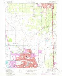
1968 Map of Lodi South
USGS Topo · Published 1980About this map
Agricultural lands and emerging residential tracts define the San Joaquin Valley landscape between Lodi and Stockton in the late 1960s. The region is heavily shaped by water management and transport, with the Mokelumne Aqueduct cutting across the terrain alongside numerous irrigation sloughs such as Pixley Slough and Bear Creek. The influence of the railroad era remains visible through the Southern Pacific, Western Pacific, and Central California Traction lines, which supported smaller depots and settlements like Tomspur and Armstrong.
Find a feature on this map
65 named features on this map. Tap any name to fly to it.
Don’t see what you’re looking for? This feature index may not catch every label — zoom into the map to look around manually.
Map Details
Editions of this 1968 Lodi South Map
3 editions found
Other maps of this area

1894 · Lodi
USGS Topo · 1:125,000

1908 · Waterloo
USGS Topo · 1:31,680

1908 · Lockeford
USGS Topo · 1:31,680

1910 · New Hope
USGS Topo · 1:31,680

1910 · Castle
USGS Topo · 1:31,680

1910 · Woodbridge
USGS Topo · 1:31,680

1910 · Headreach
USGS Topo · 1:31,680

1913 · Stockton
USGS Topo · 1:31,680

1913 · Holt
USGS Topo · 1:31,680

1914 · Burnham
USGS Topo · 1:31,680