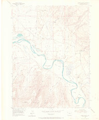
1954 Map of Lodore School
USGS Topo · Published 1967About this map
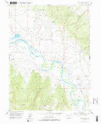
The Green River carves a winding path through this corner of Moffat County, framing a sequence of alluvial river bottoms that once sustained isolated homesteads and ranching operations. In the mid-1950s, the landscape of Brown's Park was characterized by family-named landmarks such as Wilson Place and Carr Place, alongside several sites already marked as abandoned, including Spitzie Place and Sterling Place. The Lodore Sch and the Two Bar Ranch serve as central points of human activity in this high-desert environment, where access was largely dependent on a network of unimproved roads and a Jeep Trail. To the south, the terrain rises sharply into the rugged slopes of Diamond Mountain, while Vermillion Creek joins the main river channel near Dummy Bottom. The map preserves the specific locations of several springs, such as Hoy Spring and Sterling Spring, which were vital for survival in this arid terrain.
Find a feature on this map
32 named features on this map. Tap any name to fly to it.
Don’t see what you’re looking for? This feature index may not catch every label — zoom into the map to look around manually.
Map Details
Editions of this 1954 Lodore School Map
6 editions found
Other maps of this area

1885 · Ashley
USGS Topo · 1:250,000

1952 · Willow Creek Butte
USGS Topo · 1:24,000

1952 · Swallow Canyon
USGS Topo · 1:24,000

1954 · Lodore School
USGS Topo · 1:24,000

1954 · Canyon of Lodore North
USGS Topo · 1:24,000

1954 · Vernal
USGS Topo · 1:250,000

1958 · Vernal
USGS Topo · 1:250,000

1960 · Vernal
USGS Topo · 1:250,000
1966 · Beaver Basin
USGS Topo · 1:24,000

1966 · Big Joe Basin
USGS Topo · 1:24,000