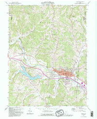
1992 Map of Logan
USGS Topo · Published 1995About this map
The Hocking River winds through this 1990s landscape, serving as the geographic anchor for Logan, West Logan, and South Logan. The river valley contains the heavy infrastructure of the era, including the Chessy System railroad lines and several industrial kilns. To the west, the expansive Lake Logan State Park surrounds Lake Logan, formed along the Clear Fork. The map provides a detailed view of the Hocking County seat, locating the local Courthouse, Post Office, and County Fairground. Beyond the urban center, the terrain is marked by numerous oil wells and legacy family landmarks such as Schultz Hill and Callico Ridge. Genealogists will find a high density of rural burial sites, from the Oak Grove Cemetery near town to more remote locations like Ruff Cem and Shaw Cem.
Find a feature on this map
65 named features on this map. Tap any name to fly to it.
Don’t see what you’re looking for? This feature index may not catch every label — zoom into the map to look around manually.
Map Details
Editions of this 1992 Logan Map
This is the sole edition of this map. No revisions or reprints were ever made.
Other maps of this area

1904 · Zaleski
USGS Topo · 1:62,500

1907 · Zaleski
USGS Topo · 1:62,500

1907 · Logan
USGS Topo · 1:62,500

1907 · Lancaster
USGS Topo · 1:62,500

1909 · Lancaster
USGS Topo · 1:62,500

1909 · Logan
USGS Topo · 1:62,500

1910 · Laurelville
USGS Topo · 1:62,500

1912 · Laurelville
USGS Topo · 1:62,500

1944 · Laurelville
USGS Topo · 1:62,500

1947 · Columbus
USGS Topo · 1:250,000