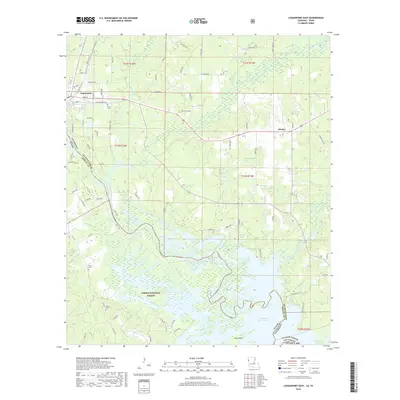
2018 Map of Logansport East
USGS Topo · Published 2018About this map
Logansport stands at the western edge of De Soto Parish, where the Louisiana border meets the Sabine National Forest of Texas. This 2018 survey documents a landscape defined by the expansive waters of the Toledo Bend Reservoir, which dominates the southern half of the quadrangle. North of the reservoir, the terrain is characterized by a dense network of creek drainages, including Bayou Grand Cane, Canadian Bayou, and Bayou Castor, flowing through a mix of wooded areas and small settlements. The community of Stanley sits at the intersection of local routes, while rural life is anchored by family-named landmarks like Price Cem, Smith Cem, and Ashton Cem. The presence of numerous unnamed roads and tracks branching off Main St and Old Mansfield Rd suggests a landscape shaped by timber management and local agriculture adjacent to the reservoir’s shoreline and Pine Island.
Find a feature on this map
97 named features on this map. Tap any name to fly to it.
Don’t see what you’re looking for? This feature index may not catch every label — zoom into the map to look around manually.
Map Details
Editions of this 2018 Logansport East Map
This is the sole edition of this map. No revisions or reprints were ever made.
Other maps of this area

1944 · Logansport
USGS Topo · 1:62,500

1945 · Grand Cane
USGS Topo · 1:62,500

1945 · Socagee Bayou
USGS Topo · 1:62,500

1953 · Alexandria
USGS Topo · 1:250,000

1953 · Palestine
USGS Topo · 1:250,000

1955 · Shreveport
USGS Topo · 1:250,000

1955 · Alexandria
USGS Topo · 1:250,000

1956 · Shreveport
USGS Topo · 1:250,000

1956 · Tyler
USGS Topo · 1:250,000

1956 · Logansport
USGS Topo · 1:62,500