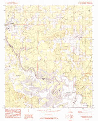
1984 Map of Logansport East
USGS Topo · Published 1984About this map
Logansport stands at the northwestern edge of this survey, where the landscape transitions into the expansive wetlands and bottomlands of the Sabine River valley. During the early 1980s, this border region between De Soto Parish, Louisiana, and Shelby County, Texas, was defined by the intricate hydrology of the Toledo Bend Reservoir. The map illustrates a complex network of bayous and branches, including Grand Cane Bayou, Castor Bayou, and Canadian Bayou, which feed into the larger river system.
Find a feature on this map
28 named features on this map. Tap any name to fly to it.
Don’t see what you’re looking for? This feature index may not catch every label — zoom into the map to look around manually.
Map Details
Editions of this 1984 Logansport East Map
This is the sole edition of this map. No revisions or reprints were ever made.
Other maps of this area

1944 · Logansport
USGS Topo · 1:62,500

1945 · Grand Cane
USGS Topo · 1:62,500

1945 · Socagee Bayou
USGS Topo · 1:62,500

1953 · Alexandria
USGS Topo · 1:250,000

1953 · Palestine
USGS Topo · 1:250,000

1955 · Shreveport
USGS Topo · 1:250,000

1955 · Alexandria
USGS Topo · 1:250,000

1956 · Shreveport
USGS Topo · 1:250,000

1956 · Tyler
USGS Topo · 1:250,000

1956 · Logansport
USGS Topo · 1:62,500