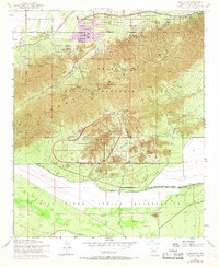
1952 Map of Lone Butte
USGS Topo · Published 1968About this map
Phoenix South Mountain Park dominates the landscape, showing the transition from the rugged mountain interior to the burgeoning outskirts of the valley in the early 1950s. The map illustrates a heavy institutional presence along the northern park boundary, including the Phoenix Police Academy, YMCA Camp, and the Phoenix Gun Club Rifle Ranges. This area reflects a mid-century period of civic development where public lands were utilized for specialized training and community recreation, including the South Mountain Speedway.
Find a feature on this map
26 named features on this map. Tap any name to fly to it.
Don’t see what you’re looking for? This feature index may not catch every label — zoom into the map to look around manually.
Map Details
Editions of this 1952 Lone Butte Map
5 editions found

Other maps of this area

1912 · Phoenix
USGS Topo · 1:62,500

1913 · Mesa
USGS Topo · 1:62,500

1913 · Maricopa
USGS Topo · 1:62,500

1914 · Gila Butte
USGS Topo · 1:62,500

1914 · Phoenix
USGS Topo · 1:62,500

1915 · Mesa
USGS Topo · 1:62,500

1915 · Maricopa
USGS Topo · 1:62,500

1917 · Gila Butte
USGS Topo · 1:62,500

1952 · Tempe
USGS Topo · 1:24,000

1952 · Gila Butte NW
USGS Topo · 1:24,000