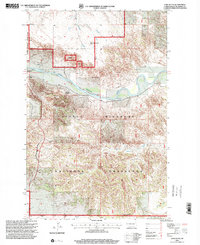
1997 Map of Lone Butte
USGS Topo · Published 2001About this map
The Little Missouri River carves a deep valley through this corner of McKenzie County, defining a landscape of dramatic topography where the river meanders through the heart of the Little Missouri National Grassland. This 1997 revision, based on surveys from the 1950s, highlights the ranching heritage of the badlands with family-named sites such as the W Dixon Ranch, W Watson Ranch, and H Baye Ranch situated near the riverbanks.
Find a feature on this map
19 named features on this map. Tap any name to fly to it.
Don’t see what you’re looking for? This feature index may not catch every label — zoom into the map to look around manually.
Map Details
Editions of this 1997 Lone Butte Map
This is the sole edition of this map. No revisions or reprints were ever made.
Other maps of this area

1953 · Watford City
USGS Topo · 1:250,000

1957 · Watford City
USGS Topo · 1:250,000

1958 · Long X Divide
USGS Topo · 1:24,000

1958 · Lone Butte SE
USGS Topo · 1:24,000

1958 · Lone Butte
USGS Topo · 1:24,000

1958 · Tepee Buttes
USGS Topo · 1:24,000

1959 · Lone Butte NW
USGS Topo · 1:24,000

1959 · Lone Butte NE
USGS Topo · 1:24,000

1967 · Watford City
USGS Topo · 1:250,000

1974 · Petes Creek
USGS Topo · 1:24,000