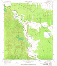
1967 Map of Lone Pine
USGS Topo · Published 1968About this map
Lone Pine and Haas occupy a landscape deeply defined by the complex water systems of central Louisiana, where the Southern Pacific railroad runs parallel to the modern infrastructure of the Bayou Boeuf-Cocodrie Diversion Channel. The map illustrates a transitional environment where agricultural fields meet dense wetland brakes, such as Hubbard Brake and Wilson Brake. Community life is anchored by several rural landmarks, including Morning Glory Ch and the settlement of Centerville, which features its own Centerville Ch. Genealogists and local historians can trace legacy footprints through sites like Johnson Cem and Griffin Cem, or locate the remnants of older transportation routes like the Old Railroad Grade. Industrial activity is marked by scattered Oil Wells and a significant Pipeline, reflecting the mid-century energy and drainage projects that reshaped the Evangeline and Rapides Parish borders.
Find a feature on this map
33 named features on this map. Tap any name to fly to it.
Don’t see what you’re looking for? This feature index may not catch every label — zoom into the map to look around manually.
Map Details
Editions of this 1967 Lone Pine Map
2 editions found
Other maps of this area

1935 · Turkey Creek
USGS Topo · 1:62,500

1935 · Lecompte
USGS Topo · 1:62,500

1940 · Marksville
USGS Topo · 1:62,500

1948 · Bunkie
USGS Topo · 1:62,500

1949 · Turkey Creek
USGS Topo · 1:62,500

1952 · Lake Charles
USGS Topo · 1:250,000

1953 · Alexandria
USGS Topo · 1:250,000

1954 · Lake Charles
USGS Topo · 1:250,000

1955 · Alexandria
USGS Topo · 1:250,000

1957 · Lecompte
USGS Topo · 1:62,500