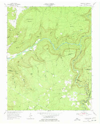
1954 Map of Lonewood
USGS Topo · Published 1977About this map
Caney Fork carves a deep path through this mid-century upland, creating a landscape defined by significant elevation changes and natural landmarks like Virgin Falls and the Gulf. Small settlements such as Lonewood and Bethesda are shown during a period of transition, with the local economy shifting toward industrial uses like the Strip Mine located in the southeastern corner. For those researching local history, the map identifies numerous family burial sites, including Lonewood Cem, Parks Cem, and Mitchell Cem, alongside natural curiosities like Dodson Cave and Rose Cave. The proximity of Big Bottom to the river highlights the importance of the narrow valley floors for agriculture and travel, while features like Cedar Shoals Ford indicate historical crossing points before modern bridge infrastructure dominated the region.
Find a feature on this map
59 named features on this map. Tap any name to fly to it.
Don’t see what you’re looking for? This feature index may not catch every label — zoom into the map to look around manually.
Map Details
Editions of this 1954 Lonewood Map
4 editions found
Other maps of this area

1892 · Pikeville
USGS Topo · 1:125,000

1895 · Pikeville
USGS Topo · 1:125,000

1909 · Sequatchie Valley
USGS Topo · 1:62,500

1910 · Pikeville
USGS Topo · 1:62,500

1912 · Crossville
USGS Topo · 1:62,500

1935 · Billingsley Gap
USGS Topo · 1:24,000

1943 · Cookeville
USGS Topo · 1:100,000

1944 · Cookeville
USGS Topo · 1:100,000

1953 · Chattanooga
USGS Topo · 1:250,000

1954 · De Rossett
USGS Topo · 1:24,000