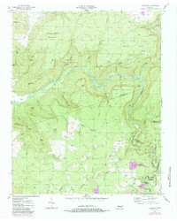
1954 Map of Lonewood
USGS Topo · Published 1984About this map
The rugged boundary between White and Van Buren counties is defined by the deep winding path of the Caney Fork. This mid-century survey captures the region just before significant preservation efforts, highlighting the Virgin Falls State Natural Area and its distinctive hydrology including Big Sink and the nearby Rose Cave. The landscape is a mix of high timber and industrial activity, evidenced by Strip Mines operating south of Lonewood.
Find a feature on this map
59 named features on this map. Tap any name to fly to it.
Don’t see what you’re looking for? This feature index may not catch every label — zoom into the map to look around manually.
Map Details
Editions of this 1954 Lonewood Map
4 editions found
Other maps of this area

1892 · Pikeville
USGS Topo · 1:125,000

1895 · Pikeville
USGS Topo · 1:125,000

1909 · Sequatchie Valley
USGS Topo · 1:62,500

1910 · Pikeville
USGS Topo · 1:62,500

1912 · Crossville
USGS Topo · 1:62,500

1935 · Billingsley Gap
USGS Topo · 1:24,000

1943 · Cookeville
USGS Topo · 1:100,000

1944 · Cookeville
USGS Topo · 1:100,000

1953 · Chattanooga
USGS Topo · 1:250,000

1954 · De Rossett
USGS Topo · 1:24,000