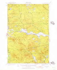
1922 Map of Long Pond
USGS Topo · Published 1957About this map
Long Pond and the Moose River corridor dominate this Somerset County landscape as it appeared in the 1920s. This survey, conducted by J.L. Gayetty and others, details the early 20th-century dependence on both the river system and the Canadian Pacific railroad. The presence of Jackman Station and Jackman Mill marks the area's industrial activity, while numerous remote outposts like Churchill Camp, Hughey Camp, and Camp No 2 suggest a robust logging and sporting culture. The map also captures agricultural efforts at the Whipple Farm and Fogg Farm. To the south, Lake Parlin and its surroundings indicate the start of the region's development as a destination for outdoor recreation, further evidenced by the Tourist Camp and various hiking paths like the Alder Brook Trail.
Find a feature on this map
82 named features on this map. Tap any name to fly to it.
Don’t see what you’re looking for? This feature index may not catch every label — zoom into the map to look around manually.
Map Details
Editions of this 1922 Long Pond Map
5 editions found
Other maps of this area

1905 · The Forks
USGS Topo · 1:62,500

1907 · The Forks
USGS Topo · 1:62,500

1921 · Brassua Lake
USGS Topo · 1:62,500

1922 · Long Pond
USGS Topo · 1:62,500

1923 · Brassua Lake
USGS Topo · 1:62,500

1923 · Attean
USGS Topo · 1:62,500

1924 · Long Pond
USGS Topo · 1:62,500

1925 · Pierce Pond
USGS Topo · 1:48,000

1925 · Attean
USGS Topo · 1:62,500

1927 · Sandy Bay
USGS Topo · 1:48,000