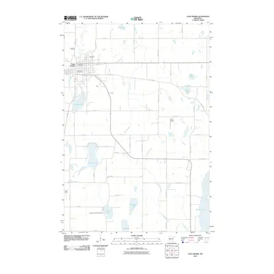
2010 Map of Long Prairie
USGS Topo · Published 2010About this map
Long Prairie serves as the focal point of this Todd County landscape, situated along the winding course of the Long Prairie River. The settlement pattern reflects its role as a regional hub, evidenced by the Todd County Fairgrounds and the central Long Prairie Post Office. Beyond the town grid, the terrain is defined by a dense concentration of glacial lakes and wetlands, including Charlotte Lake, Latimer Lake, and the expansive Big Swan Lake on the eastern edge. Local history is preserved at the Saint Mary Cemetery and Long Prairie Cemetery, while the presence of Todd Field and the Bernard Fry Structure Dam on Center Lake highlights more modern infrastructure. The map also details a network of rural routes like County Hwy-12 that connect these water bodies and agricultural lands, providing a clear view of the area's physical and social geography in the early 21st century.
Find a feature on this map
53 named features on this map. Tap any name to fly to it.
Don’t see what you’re looking for? This feature index may not catch every label — zoom into the map to look around manually.
Map Details
Editions of this 2010 Long Prairie Map
This is the sole edition of this map. No revisions or reprints were ever made.
Other maps of this area

1948 · Cushing
USGS Topo · 1:62,500

1950 · Swanville
USGS Topo · 1:62,500

1950 · Cushing
USGS Topo · 1:62,500

1953 · Brainerd
USGS Topo · 1:250,000

1953 · Saint Cloud
USGS Topo · 1:250,000

1957 · Brainerd
USGS Topo · 1:250,000

1957 · Saint Cloud
USGS Topo · 1:250,000

1958 · Saint Cloud
USGS Topo · 1:250,000

1958 · Brainerd
USGS Topo · 1:250,000

1965 · Brainerd
USGS Topo · 1:250,000