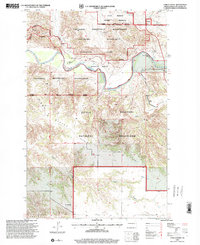
1997 Map of Long X Divide
USGS Topo · Published 2001About this map
Little Missouri River serpentines through the heart of this North Dakota badlands landscape, defining the northern reaches of Theodore Roosevelt National Park (North Unit). This 1997 revision captures a transition in land management and recreation, where cattle ranching interests like the T Tarnavsky Ranch and C Lange Ranch neighbor the expansive Little Missouri National Grassland. The terrain is dominated by the prominent Long X Divide, a high ridge that separates drainage patterns toward the river and its tributaries such as Corral Creek. For those tracing historical movement through the Missouri Plateau, the map highlights the intersection of working ranch roads with established recreation routes, including the Maah Daah Hey Trail and the namesake Long X Trail. Evidence of federal oversight and environmental monitoring is found at the Park Ranger Station and the riverside Gaging Station near the park boundary.
Find a feature on this map
17 named features on this map. Tap any name to fly to it.
Don’t see what you’re looking for? This feature index may not catch every label — zoom into the map to look around manually.
Map Details
Editions of this 1997 Long X Divide Map
This is the sole edition of this map. No revisions or reprints were ever made.
Other maps of this area

1953 · Watford City
USGS Topo · 1:250,000

1957 · Watford City
USGS Topo · 1:250,000

1958 · Long X Divide
USGS Topo · 1:24,000

1958 · Sperati Point
USGS Topo · 1:24,000

1958 · Lone Butte
USGS Topo · 1:24,000

1958 · Stocke Butte
USGS Topo · 1:24,000

1958 · Tepee Buttes
USGS Topo · 1:24,000

1959 · Lone Butte NW
USGS Topo · 1:24,000

1967 · Watford City
USGS Topo · 1:250,000

1974 · Wolf Coulee
USGS Topo · 1:24,000