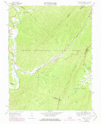
1969 Map of Longdale Furnace
USGS Topo · Published 1978About this map
The Longdale Furnace industrial site and surrounding mountain gaps dominate this late-1960s survey of the Virginia highlands. Situated along Simpson Creek, the area showcases a landscape deeply defined by its transport and resource history, from the Chesapeake and Ohio Grade and Colemans Tunnel in the north to the scattered community clusters of Griffith, Pads, and Nicelytown. The topography is marked by the presence of both the George Washington National Forest and Jefferson National Forest, with North Mountain and Brushy Mountain framing the narrow valleys. Evidence of rural community life is preserved through numerous ecclesiastical landmarks such as Sharon Ch, Lone Star Ch, and Cedar Grove Ch, along with the Sharon Sch. This map documents a period of transition, including 1970s photorevisions that highlight road developments and the established Longdale Recreation Area.
Find a feature on this map
38 named features on this map. Tap any name to fly to it.
Don’t see what you’re looking for? This feature index may not catch every label — zoom into the map to look around manually.
Map Details
Editions of this 1969 Longdale Furnace Map
Other maps of this area

1894 · Natural Bridge
USGS Topo · 1:125,000

1894 · Natural Bridge
USGS Topo · 1:62,500

1907 · Natural Bridge Special
USGS Topo · 1:62,500

1913 · Eagle Rock
USGS Topo · 1:48,000

1915 · Eagle Rock
USGS Topo · 1:62,500

1931 · Healing Springs
USGS Topo · 1:24,000

1933 · Healing Springs
USGS Topo · 1:31,680

1945 · Clifton Forge
USGS Topo · 1:62,500

1946 · Millboro
USGS Topo · 1:62,500

1947 · Roanoke
USGS Topo · 1:250,000