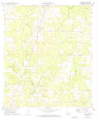
1972 Map of Longstreet
USGS Topo · Published 1974About this map
The Southern Pacific railroad line anchors the settlement of Longstreet in the northwest corner of De Soto Parish during the early 1970s. This survey illustrates a landscape defined by its natural drainage and extractive industry, where Bushneck Bayou, Castor Bayou, and Canadian Bayou wind through the terrain. The southern half of the map is dominated by the Logansport Oil and Gas Field, marked by numerous pipeline corridors and a Drill Hole that underscore the region's mid-century economic reliance on energy production.
Find a feature on this map
22 named features on this map. Tap any name to fly to it.
Don’t see what you’re looking for? This feature index may not catch every label — zoom into the map to look around manually.
Map Details
Editions of this 1972 Longstreet Map
This is the sole edition of this map. No revisions or reprints were ever made.
Other maps of this area

1944 · Logansport
USGS Topo · 1:62,500

1945 · Grand Cane
USGS Topo · 1:62,500

1945 · Socagee Bayou
USGS Topo · 1:62,500

1953 · Alexandria
USGS Topo · 1:250,000

1953 · Palestine
USGS Topo · 1:250,000

1955 · Shreveport
USGS Topo · 1:250,000

1955 · Alexandria
USGS Topo · 1:250,000

1956 · Shreveport
USGS Topo · 1:250,000

1956 · Tyler
USGS Topo · 1:250,000

1956 · Logansport
USGS Topo · 1:62,500