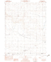
1982 Map of Longview
USGS Topo · Published 1983About this map
Agricultural life in southern Champaign and Douglas Counties centers on a series of small rural communities connected by the Missouri Pacific railroad. The village of Longview is the primary hub, situated near the confluence of Long Point Slough and the drainage network of the East Branch Embarras River. To the west and north, smaller settlements like Bongard and Block serve the surrounding farmsteads, which are punctuated by local landmarks including the Immaculate Conception Ch and Lynn Grove Cem.
Find a feature on this map
24 named features on this map. Tap any name to fly to it.
Don’t see what you’re looking for? This feature index may not catch every label — zoom into the map to look around manually.
Map Details
Editions of this 1982 Longview Map
This is the sole edition of this map. No revisions or reprints were ever made.
Other maps of this area
1906 · Urbana
USGS Topo · 1:62,500
1931 · Fithian
USGS Topo · 1:48,000
1943 · Fithian
USGS Topo · 1:62,500

1953 · Danville
USGS Topo · 1:250,000

1953 · Indianapolis
USGS Topo · 1:250,000

1955 · Danville
USGS Topo · 1:250,000

1956 · Danville
USGS Topo · 1:250,000

1956 · Indianapolis
USGS Topo · 1:250,000
1956 · Newman
USGS Topo · 1:62,500
1956 · Villa Grove
USGS Topo · 1:62,500