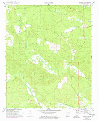
1972 Map of Lonsdale NE
USGS Topo · Published 1977About this map
The Alum Fork Saline River and the Middle Fork Saline River converge in this Saline County landscape, dictating the settlement and agricultural patterns of the early 1970s. The map illustrates a region defined by its drainage basins and ridges, most notably the prominent Prillman Ridge to the north. Surveyors marked the primary east-west Base Line across this quadrangle, which serves as a fundamental cadastral reference point for the surrounding township and range divisions.
Find a feature on this map
10 named features on this map. Tap any name to fly to it.
Don’t see what you’re looking for? This feature index may not catch every label — zoom into the map to look around manually.
Map Details
Editions of this 1972 Lonsdale NE Map
4 editions found
Other maps of this area

1890 · Benton
USGS Topo · 1:125,000

1894 · Benton
USGS Topo · 1:125,000

1938 · Benton
USGS Topo · 1:48,000

1944 · Benton
USGS Topo · 1:62,500

1955 · Little Rock
USGS Topo · 1:250,000

1956 · Little Rock
USGS Topo · 1:250,000

1960 · Little Rock
USGS Topo · 1:250,000

1963 · Paron SW
USGS Topo · 1:24,000

1963 · Fourche SW
USGS Topo · 1:24,000

1963 · Paron
USGS Topo · 1:24,000