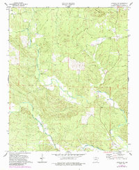
1972 Map of Lonsdale NE
USGS Topo · Published 1984About this map
The Alum Fork Saline River and Middle Fork Saline River converge in this northern Saline County landscape, creating a complex network of drainages that defined local settlement patterns in the early 1970s. The terrain is marked by prominent elevations like Frillman Ridge, which directs the flow of smaller tributaries such as Lees Creek. This survey reveals a community anchored by rural landmarks, where the Base Line survey marker cuts across the hills. Genealogists can identify several key family and community sites, including Bolin Cem and Wesleys Chapel Cem, alongside local congregations at Unity Landmark Ch and Gravel Hill Ch. The map reflects a period of transition, with original 1972 data updated with 1982 photorevisions to show changes in rural roads and land use near the Geurin Cem area.
Find a feature on this map
10 named features on this map. Tap any name to fly to it.
Don’t see what you’re looking for? This feature index may not catch every label — zoom into the map to look around manually.
Map Details
Editions of this 1972 Lonsdale NE Map
4 editions found
Other maps of this area

1890 · Benton
USGS Topo · 1:125,000

1894 · Benton
USGS Topo · 1:125,000

1938 · Benton
USGS Topo · 1:48,000

1944 · Benton
USGS Topo · 1:62,500

1955 · Little Rock
USGS Topo · 1:250,000

1956 · Little Rock
USGS Topo · 1:250,000

1960 · Little Rock
USGS Topo · 1:250,000

1963 · Paron SW
USGS Topo · 1:24,000

1963 · Fourche SW
USGS Topo · 1:24,000

1963 · Paron
USGS Topo · 1:24,000