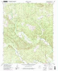
1972 Map of Lonsdale NE
USGS Topo · Published 1984About this map
The Middle Fork Saline River and the Alum Fork Saline River converge in this Arkansas river valley, shaping a landscape defined by sharp ridges and deep creek bottoms. By the early 1970s, this portion of Saline County remained largely rural, anchored by small community centers like Gravel Hill Ch and Unity Landmark Ch. The map provides significant genealogical value through its documentation of secluded family and church burial grounds, including Bolin Cem, Geurin Cem, and Wesleys Chapel Cem. Notable topographical landmarks such as Prittman Ridge dominate the northern terrain, while the South Fork Saline River cuts through the southwestern corner. The presence of the Base Line and various township markers illustrates the foundational land surveying that organized this wooded territory.
Find a feature on this map
14 named features on this map. Tap any name to fly to it.
Don’t see what you’re looking for? This feature index may not catch every label — zoom into the map to look around manually.
Map Details
Editions of this 1972 Lonsdale NE Map
4 editions found
Other maps of this area

1890 · Benton
USGS Topo · 1:125,000

1894 · Benton
USGS Topo · 1:125,000

1938 · Benton
USGS Topo · 1:48,000

1944 · Benton
USGS Topo · 1:62,500

1955 · Little Rock
USGS Topo · 1:250,000

1956 · Little Rock
USGS Topo · 1:250,000

1960 · Little Rock
USGS Topo · 1:250,000

1963 · Paron SW
USGS Topo · 1:24,000

1963 · Fourche SW
USGS Topo · 1:24,000

1963 · Paron
USGS Topo · 1:24,000