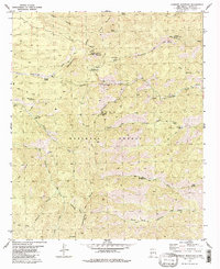
1981 Map of Lookout Mountain
USGS Topo · Published 1981About this map
The Continental Divide winds through the high country of the Gila National Forest, defining a landscape of deep canyons and mining history. This 1981 record shows a network of remote activity concentrated around the Silver Monument Mine and McTavish Mine, where prospecting and extraction followed the drainages of Chloride Creek. A central point for forest management is indicated by the Lookout Tower atop Lookout Mountain, supported by the nearby Monument Park Guard Station.
Find a feature on this map
40 named features on this map. Tap any name to fly to it.
Don’t see what you’re looking for? This feature index may not catch every label — zoom into the map to look around manually.
Map Details
Editions of this 1981 Lookout Mountain Map
2 editions found
Other maps of this area

1949 · Lookout Mountain
USGS Topo · 1:62,500

1954 · Tularosa
USGS Topo · 1:250,000

1958 · Tularosa
USGS Topo · 1:250,000

1963 · Bonner Canyon
USGS Topo · 1:24,000

1963 · Reeds Peak
USGS Topo · 1:24,000

1963 · Sugarloaf Peak
USGS Topo · 1:24,000

1965 · Winston
USGS Topo · 1:24,000

1965 · Iron Mountain
USGS Topo · 1:24,000

1979 · Truth or Consequences
USGS Topo · 1:100,000
1981 · Taylor Peak
USGS Topo · 1:24,000