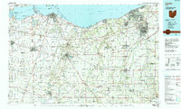
1986 Map of Lorain
USGS Topo · Published 1990About this map
The industrial and recreational shoreline of Lake Erie defines this mid-1980s portrait of Northern Ohio. Major population centers like Lorain, Elyria, and Sandusky appear alongside established transit corridors, including the Ohio Turnpike and significant rail lines operated by Conrail and the Norfolk and Western Railroad. The map documents the intricate hydrology of the region, from the wide expanse of Sandusky Bay to the winding courses of the Huron River and Vermilion River. Notable landmarks such as Cedar Point and Johnson Island provide geographical anchors for the coastline, while inland, the landscape is punctuated by agricultural hubs like Norwalk and Bellevue. Conservation and water management are evident through features like Resthaven State Wildlife Management Area and the Wellington Reservoir, illustrating how the land was utilized for both industry and public resource protection during this era.
Find a feature on this map
90 named features on this map. Tap any name to fly to it.
Don’t see what you’re looking for? This feature index may not catch every label — zoom into the map to look around manually.
Map Details
Editions of this 1986 Lorain Map
2 editions found
Other maps of this area

1900 · Oak Harbor
USGS Topo · 1:62,500

1901 · Oberlin
USGS Topo · 1:62,500

1901 · Put-In-Bay
USGS Topo · 1:62,500

1901 · Bellevue
USGS Topo · 1:62,500

1901 · Fremont
USGS Topo · 1:62,500

1901 · Wooster
USGS Topo · 1:62,500

1902 · Berea
USGS Topo · 1:62,500

1903 · Bellevue
USGS Topo · 1:62,500

1903 · Vermilion
USGS Topo · 1:62,500

1903 · Fremont
USGS Topo · 1:62,500