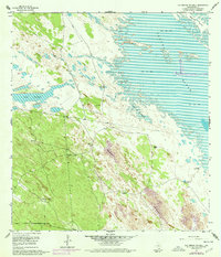
1956 Map of Los Amigos Windmill
USGS Topo · Published 1978About this map
Water management defines life in this Kenedy County landscape, where the expanse of Laguna Madre meets a coastal plain dominated by shifting sand dunes. The 1956 topography, updated in the mid-1970s, reveals a network of named wells and windmills essential for ranching in an area of frequent tidal inundation. Clusters of infrastructure like the Los Amigos Windmill and Santa Cruz Windmill dot the interior, while artesian sources such as Andres Artesian Well and Toro Artesian Well are situated closer to the sand and mud flats of the shoreline. The interaction between the maritime environment of Cayo Soledad and the terrestrial ranching features provides a detailed look at the rural economy of the Texas Gulf Coast during this era. Long stretches of fence lines crisscross the terrain, marking property boundaries and grazing divisions across the Rincon de la Soledad.
Find a feature on this map
20 named features on this map. Tap any name to fly to it.
Don’t see what you’re looking for? This feature index may not catch every label — zoom into the map to look around manually.
Map Details
Editions of this 1956 Los Amigos Windmill Map
2 editions found
Other maps of this area

1921 · Tarida Ranch
USGS Topo · 1:62,500

1923 · Lopena Island
USGS Topo · 1:62,500

1923 · Saltillo Ranch
USGS Topo · 1:62,500

1951 · Potrero Lopeno NW
USGS Topo · 1:24,000

1952 · South of Potrero Lopeno NW
USGS Topo · 1:24,000

1952 · Potrero Lopeno SW
USGS Topo · 1:24,000

1952 · Potrero Lopeno
USGS Topo · 1:62,500

1952 · South of Potrero Lopeno
USGS Topo · 1:62,500

1953 · Brownsville
USGS Topo · 1:250,000
1956 · San Pedro Ranch
USGS Topo · 1:24,000