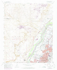
1960 Map of Los Griegos
USGS Topo · Published 1975About this map
The Rio Grande valley north of Albuquerque is defined by a dense network of irrigation and drainage infrastructure, including the Corrales Main Canal and the Albuquerque Riverside Drain. This mid-century landscape shows the transition from historic land grants like the Town of Alameda Grant to burgeoning suburban developments. The map reveals the expansion of Rio Rancho Estates and Paradise Hills onto the western mesas, contrasting with the established agrarian character of Los Poblanos Ranch and Corrales along the riverbanks. Civil and educational life is well-documented through landmarks like the Alameda Airport, St Joseph College, and numerous neighborhood institutions such as Griegos Sch and Trinity Sch. The inclusion of various laterals and drains, such as the Griegos Lateral and Chamizal Lateral, illustrates the complex water management essential to the valley’s local economy and settlement pattern during this era.
Find a feature on this map
50 named features on this map. Tap any name to fly to it.
Don’t see what you’re looking for? This feature index may not catch every label — zoom into the map to look around manually.
Map Details
Editions of this 1960 Los Griegos Map
Other maps of this area

1888 · Bernalillo
USGS Topo · 1:125,000

1889 · Albuquerque
USGS Topo · 1:125,000

1893 · Albuquerque
USGS Topo · 1:125,000

1934 · Alameda
USGS Topo · 1:24,000

1934 · West Albuquerque
USGS Topo · 1:24,000

1934 · Griegos
USGS Topo · 1:24,000

1934 · East Albuquerque
USGS Topo · 1:24,000

1938 · Albuquerque
USGS Topo · 1:62,500

1954 · Alameda
USGS Topo · 1:24,000

1954 · Volcano Ranch
USGS Topo · 1:24,000