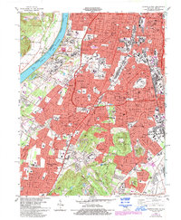
1983 Map of Louisville West
USGS Topo · Published 1994About this map
Iroquois Park dominates the southeastern quadrant of this study, its forested slopes rising sharply above the dense urban grid of Louisville. This era reflects a period of significant suburban expansion and industrial infrastructure, where the U S Naval Ordnance Plant and several railroad networks, including the Illinois Central Gulf RR, delineate the economic character of the region. The map tracks the western edge of the city toward the Ohio River, passing through established neighborhoods like Shively and Pleasure Ridge Park. To the west, the landscape shifts toward the river bottomlands near Lake Dreamland, while the south is marked by the heights of Waverly Hills. Genealogists will find high value in the numerous cemeteries and schools, from St Stephens Cem to localized institutions like Butler High Sch and Iroquois High Sch.
Find a feature on this map
65 named features on this map. Tap any name to fly to it.
Don’t see what you’re looking for? This feature index may not catch every label — zoom into the map to look around manually.
Map Details
Editions of this 1983 Louisville West Map
3 editions found
Other maps of this area

1905 · Prospect
USGS Topo · 1:62,500

1907 · Louisville
USGS Topo · 1:62,500

1909 · Kosmosdale
USGS Topo · 1:48,000

1912 · Prospect
USGS Topo · 1:62,500

1912 · Kosmosdale
USGS Topo · 1:62,500

1937 · Jeffersonville
USGS Topo · 1:24,000

1939 · New Albany
USGS Topo · 1:24,000

1939 · Georgetown
USGS Topo · 1:24,000

1946 · Jeffersonville
USGS Topo · 1:24,000

1946 · New Albany
USGS Topo · 1:24,000