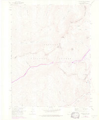
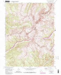
1958 Map of Loveland Pass
USGS Topo · Published 1976About this map
The Continental Divide winds across this high-altitude landscape, separating the headwaters of the Middle Fork Williams Fork from the Atlantic-bound drainage of Clear Creek. This 1958 field survey, updated with 1974 revisions, documents a critical era of transcontinental transportation as the Eisenhower Memorial Tunnel creates a passage through the granite of Coon Hill. To the west, the Straight Creek valley descends toward the Blue River basin, while the eastern slopes are dominated by the burgeoning Loveland Ski Area and the massive forms of Mount Bethel and Mount Trelease. The map illustrates the stark contrast between the industrial engineering of the tunnel and the wild terrain of the Arapaho National Forest, showing how modern infrastructure began to traverse the Williams Fork Mountains at nearly twelve thousand feet.
Find a feature on this map
30 named features on this map. Tap any name to fly to it.
Don’t see what you’re looking for? This feature index may not catch every label — zoom into the map to look around manually.
Map Details
Editions of this 1958 Loveland Pass Map
5 editions found
Other maps of this area

1924 · Montezuma
USGS Topo · 1:62,500

1924 · Fraser
USGS Topo · 1:62,500

1926 · Fraser
USGS Topo · 1:62,500

1926 · Montezuma
USGS Topo · 1:62,500

1929 · Dillon
USGS Topo · 1:62,500

1933 · Montezuma
USGS Topo · 1:62,500

1933 · Ute Peak
USGS Topo · 1:62,500

1934 · Dillon
USGS Topo · 1:62,500

1937 · Ute Peak
USGS Topo · 1:62,500

1953 · Denver
USGS Topo · 1:250,000