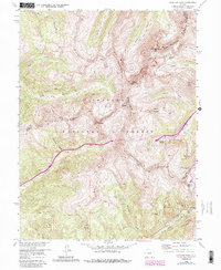
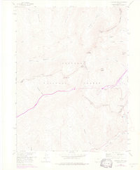
1958 Map of Loveland Pass
USGS Topo · Published 1988About this map
The Continental Divide winds through this high-altitude terrain, marking a dramatic boundary where the headwaters of the Snake River Falls and Clear Creek diverge toward different oceans. The landscape is defined by its massive peaks, including Pettingell Peak, Hagar Mountain, and Mount Bethel, which dwarf the transit corridors below. This 1958 survey, updated with revisions through the 1980s, captures the modernization of mountain travel through the inclusion of the Eisenhower Memorial Tunnel.
Find a feature on this map
32 named features on this map. Tap any name to fly to it.
Don’t see what you’re looking for? This feature index may not catch every label — zoom into the map to look around manually.
Map Details
Editions of this 1958 Loveland Pass Map
5 editions found
Other maps of this area

1924 · Montezuma
USGS Topo · 1:62,500

1924 · Fraser
USGS Topo · 1:62,500

1926 · Fraser
USGS Topo · 1:62,500

1926 · Montezuma
USGS Topo · 1:62,500

1929 · Dillon
USGS Topo · 1:62,500

1933 · Montezuma
USGS Topo · 1:62,500

1933 · Ute Peak
USGS Topo · 1:62,500

1934 · Dillon
USGS Topo · 1:62,500

1937 · Ute Peak
USGS Topo · 1:62,500

1953 · Denver
USGS Topo · 1:250,000