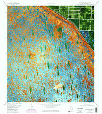
1970 Map of Loxahatchee SE
USGS Topo · Published 1984About this map
The Loxahatchee National Wildlife Refuge dominates this orthophotomap, showcasing a landscape of wet prairies and sawgrass ridges as they appeared in the 1970s and early 1980s. This portion of Conservation Area No 1 is defined by the sharp transition between the undeveloped glades and the organized water management infrastructure to the northeast. The L-40 Canal forms a rigid boundary line, punctuated by a Pump and elevation markers such as BM 18. This survey reflects the mid-century effort to balance environmental preservation with the hydraulic engineering required for South Florida's growth, capturing the intricate texture of the swamp vegetation in high contrast against the man-made canals and agricultural grids that border the refuge.
Find a feature on this map
6 named features on this map. Tap any name to fly to it.
Don’t see what you’re looking for? This feature index may not catch every label — zoom into the map to look around manually.
Map Details
Editions of this 1970 Loxahatchee SE Map
3 editions found
Other maps of this area

1945 · Greenacres City
USGS Topo · 1:24,000

1946 · Palm Beach Farms
USGS Topo · 1:24,000

1947 · Delmar Farms
USGS Topo · 1:24,000

1949 · Palm Beach Farms
USGS Topo · 1:24,000

1949 · Delmar Farms
USGS Topo · 1:24,000

1950 · Greenacres City
USGS Topo · 1:24,000

1956 · West Palm Beach
USGS Topo · 1:250,000

1957 · West Palm Beach
USGS Topo · 1:250,000

1958 · West Palm Beach
USGS Topo · 1:250,000
1962 · University Park
USGS Topo · 1:24,000