
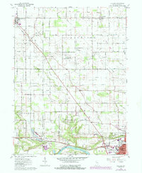
1960 Map of Lucerne
USGS Topo · Published 1963About this map
The Old Indian Treaty Boundary slices diagonally across the northern townships of this Cass County landscape, marking a historical frontier long since overlaid by a rigid section grid of rural roads. Between the primary agricultural centers of Royal Center and Lucerne, a network of drainage infrastructure like Umbenhour Ditch and Forgey Ditch illustrates the heavy management of the local watershed to support productive Indiana farmland. Along the southern edge, the terrain shifts significantly as it approaches the Wabash River and the industrial outskirts of Logansport. Here, the rail-driven economy is evident where the Pennsylvania railroad line connects the river valley to the northern settlements. Local genealogists will find several rural landmarks of interest, including the Crooked Creek Cem, Webb Chapel, and the Township Sch, which served the outlying farm families during this mid-century period.
Find a feature on this map
41 named features on this map. Tap any name to fly to it.
Don’t see what you’re looking for? This feature index may not catch every label — zoom into the map to look around manually.
Map Details
Editions of this 1960 Lucerne Map
2 editions found
Other maps of this area

1953 · Danville
USGS Topo · 1:250,000

1955 · Danville
USGS Topo · 1:250,000

1955 · Logansport
USGS Topo · 1:24,000

1955 · Anoka
USGS Topo · 1:24,000

1956 · Danville
USGS Topo · 1:250,000

1960 · Fulton
USGS Topo · 1:24,000

1960 · Grass Creek
USGS Topo · 1:24,000

1962 · Burrows
USGS Topo · 1:24,000

1962 · Star City
USGS Topo · 1:24,000

1962 · Burnettsville
USGS Topo · 1:24,000