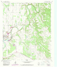
1965 Map of Lueders East
USGS Topo · Published 1987About this map
Lueders and the surrounding borderlands of Jones and Shackelford counties are defined here by the winding course of the Clear Fork Brazos River. This 1960s landscape is a complex intersection of natural drainage and industrial extraction, where multiple Quarries and gravel pits operate alongside an extensive Oil Field and a network of pipelines. The map documents the local social fabric through landmarks like the Lueders Encampment and the Lueders Cem, both situated near the river's path. Elevation changes are most pronounced at Swager Bluff, which overlooks the river valley. Numerous creeks, including Pinto Creek and Post Oak Creek, feed into the Brazos system, while the presence of scattered Oil Wells and Water Tanks across the countryside illustrates the mid-century infrastructure required to support both ranching and energy production in this part of North Central Texas.
Find a feature on this map
23 named features on this map. Tap any name to fly to it.
Don’t see what you’re looking for? This feature index may not catch every label — zoom into the map to look around manually.
Map Details
Editions of this 1965 Lueders East Map
2 editions found

Other maps of this area

1891 · Anson
USGS Topo · 1:125,000

1892 · Albany
USGS Topo · 1:125,000

1893 · Albany
USGS Topo · 1:125,000

1893 · Anson
USGS Topo · 1:125,000

1954 · Abilene
USGS Topo · 1:250,000

1957 · Nugent
USGS Topo · 1:62,500

1958 · Abilene
USGS Topo · 1:250,000

1965 · Acampo
USGS Topo · 1:24,000

1965 · Lueders NW
USGS Topo · 1:24,000

1965 · Lueders NE
USGS Topo · 1:24,000