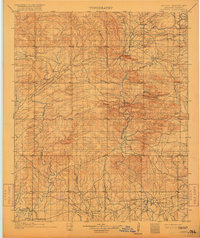
1902 Map of Lukfata
USGS Topo · Published 1917About this map
The Choctaw Nation territory shown here in the 1890s is defined by the winding course of the Mountain Fork River and its numerous tributaries. Small settlements such as Hochatown, Bethel, and Smithville are connected by a sparse network of trails and roads that follow the valley floors between the Pine Mountains and the Winding Stair range. The landscape reflects a burgeoning frontier economy, with commerce centers like Williams Store and critical river crossings like Kirks Ferry serving as vital links for the residents of the era.
Find a feature on this map
63 named features on this map. Tap any name to fly to it.
Don’t see what you’re looking for? This feature index may not catch every label — zoom into the map to look around manually.
Map Details
Editions of this 1902 Lukfata Map
3 editions found
Other maps of this area

1890 · Poteau Mountain
USGS Topo · 1:125,000

1899 · Poteau Mountain
USGS Topo · 1:125,000

1900 · Winding Stair
USGS Topo · 1:125,000

1901 · Tuskahoma
USGS Topo · 1:125,000

1901 · Alikchi
USGS Topo · 1:125,000

1902 · Lukfata
USGS Topo · 1:125,000

1908 · Tuskahoma
USGS Topo · 1:125,000

1909 · Tuskahoma
USGS Topo · 1:125,000

1909 · Winding Stair
USGS Topo · 1:125,000

1913 · De Queen
USGS Topo · 1:125,000