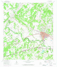
1964 Map of Luling
USGS Topo · Published 1975About this map
The Luling Oil Field dominates this 1960s landscape, with numerous Oil Wells scattered across the undulating terrain between Stairtown and the city of Luling. This area is fundamentally defined by the intersection of industrial development and local heritage, where the Southern Pacific railroad runs parallel to the winding course of the San Marcos River. The map records a high density of small family and community burial grounds, including Highsmith Cemeteries, Prairie Lea Cem, and the Ussery Cem, which suggest an older pattern of rural settlement that persists alongside the oil infrastructure.
Find a feature on this map
38 named features on this map. Tap any name to fly to it.
Don’t see what you’re looking for? This feature index may not catch every label — zoom into the map to look around manually.
Map Details
Editions of this 1964 Luling Map
3 editions found
Other maps of this area

1911 · San Marcos
USGS Topo · 1:125,000

1919 · San Marcos
USGS Topo · 1:125,000

1924 · San Marcos 3-d
USGS Topo · 1:48,000

1925 · San Marcos 4-c
USGS Topo · 1:48,000

1925 · San Marcos 1-d
USGS Topo · 1:48,000

1925 · San Marcos 4-a
USGS Topo · 1:48,000

1929 · Luling
USGS Topo · 1:62,500

1930 · Lockhart
USGS Topo · 1:62,500

1930 · Seguin
USGS Topo · 1:62,500

1953 · Seguin
USGS Topo · 1:250,000