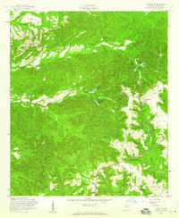
1955 Map of Lumpkin SW
USGS Topo · Published 1959About this map
Providence Canyons dominate the center of this Georgia landscape, illustrating the dramatic geological shifts of the mid-20th century. This 1955 field-checked survey reveals a rural community structured around its spiritual and educational hubs, such as Mount Moriah Ch and Providence Ch. For genealogists, the map provides precise locations for family burial grounds including the James Templeton Cem and the combined grounds of Stephen Chapel (Bluff Springs Cem).
Find a feature on this map
23 named features on this map. Tap any name to fly to it.
Don’t see what you’re looking for? This feature index may not catch every label — zoom into the map to look around manually.
Map Details
Editions of this 1955 Lumpkin SW Map
4 editions found

Other maps of this area

1949 · Julia
USGS Topo · 1:24,000

1950 · Louvale
USGS Topo · 1:24,000

1950 · Lumpkin
USGS Topo · 1:24,000

1950 · Lumpkin SW
USGS Topo · 1:24,000

1950 · Lumpkin
USGS Topo · 1:62,500

1953 · Dothan
USGS Topo · 1:250,000

1954 · Dothan
USGS Topo · 1:250,000

1955 · Dothan
USGS Topo · 1:250,000

1955 · Lumpkin
USGS Topo · 1:24,000
1955 · Louvale
USGS Topo · 1:24,000