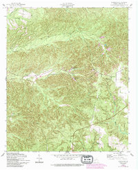
1955 Map of Lumpkin SW
USGS Topo · Published 1993About this map
Providence Canyon State Park dominates this section of Stewart County, showcasing the dramatic geological formations known as the Providence Canyons. These massive gullies, including the North Glory Hole and South Glory Hole, reveal a landscape heavily impacted by historical land use and erosional forces. Cultural landmarks are scattered throughout the rural terrain, with established congregations at Mount Moriah Ch, Wesley Chapel, and the Providence Ch near the park's edge. The map captures a moment of transition where traditional community centers like Bryan Sch and Bluff Springs Sch stand alongside newer industrial footprints, such as a nearby Strip Mine. Genealogists may find particular value in the documentation of the James Templeton Cem and the combined site of Stephen Chapel and its associated cemetery.
Find a feature on this map
22 named features on this map. Tap any name to fly to it.
Don’t see what you’re looking for? This feature index may not catch every label — zoom into the map to look around manually.
Map Details
Editions of this 1955 Lumpkin SW Map
4 editions found

Other maps of this area

1949 · Julia
USGS Topo · 1:24,000

1950 · Louvale
USGS Topo · 1:24,000

1950 · Lumpkin
USGS Topo · 1:24,000

1950 · Lumpkin SW
USGS Topo · 1:24,000

1950 · Lumpkin
USGS Topo · 1:62,500

1953 · Dothan
USGS Topo · 1:250,000

1954 · Dothan
USGS Topo · 1:250,000

1955 · Dothan
USGS Topo · 1:250,000

1955 · Lumpkin
USGS Topo · 1:24,000
1955 · Louvale
USGS Topo · 1:24,000