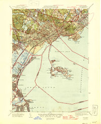
1946 Map of Lynn
USGS Topo · Published 1946About this map
The rocky Massachusetts coastline and its industrial hubs are surveyed here just after the war. The North Shore landscape is defined by the dense residential grids of West Lynn and East Lynn, bordered by the sprawling greenery of Lynn Woods and its interior heights like Mt Gilead and Burrill Hill. Along the waterfront, the coastal geography is particularly intricate, featuring the narrow neck of Little Nahant leading to the main peninsula of Nahant. Here, the map details numerous maritime landmarks such as Swallow Cave, Spouting Horn, and the offshore Egg Rock.
Find a feature on this map
108 named features on this map. Tap any name to fly to it.
Don’t see what you’re looking for? This feature index may not catch every label — zoom into the map to look around manually.
Map Details
Editions of this 1946 Lynn Map
3 editions found
Other maps of this area

1886 · Lawrence
USGS Topo · 1:62,500

1888 · Lawrence
USGS Topo · 1:62,500

1888 · Salem
USGS Topo · 1:62,500

1892 · Boston Bay
USGS Topo · 1:62,500

1893 · Salem
USGS Topo · 1:62,500

1893 · Boston
USGS Topo · 1:62,500

1893 · Lawrence
USGS Topo · 1:62,500

1903 · Boston
USGS Topo · 1:62,500

1903 · Boston Bay
USGS Topo · 1:62,500

1917 · Salem
USGS Topo · 1:62,500