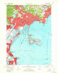
1956 Map of Lynn
USGS Topo · Published 1965About this map
The urbanized coastline of Lynn and its surrounding coastal communities are captured here in the mid-1950s, a period of dense residential growth and established maritime industry. The industrial corridor follows the Boston and Maine railroad line, while the coastline transitions from the commercial wharves of Lynn Harbor to the recreation-focused shores of Nahant Bay. Further inland, the expansive Lynn Woods and numerous water bodies like Walden Pond and Breeds Pond provide a stark contrast to the tightly packed neighborhoods of East Lynn and West Lynn.
Find a feature on this map
133 named features on this map. Tap any name to fly to it.
Don’t see what you’re looking for? This feature index may not catch every label — zoom into the map to look around manually.
Map Details
Editions of this 1956 Lynn Map
4 editions found
Other maps of this area

1886 · Lawrence
USGS Topo · 1:62,500

1888 · Lawrence
USGS Topo · 1:62,500

1888 · Salem
USGS Topo · 1:62,500

1892 · Boston Bay
USGS Topo · 1:62,500

1893 · Salem
USGS Topo · 1:62,500

1893 · Boston
USGS Topo · 1:62,500

1893 · Lawrence
USGS Topo · 1:62,500

1903 · Boston
USGS Topo · 1:62,500

1903 · Boston Bay
USGS Topo · 1:62,500

1917 · Salem
USGS Topo · 1:62,500